
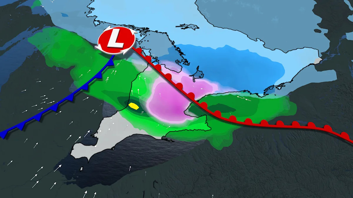
Spring arrived on the calendar, but nobody told the weather. Eastern Ontario and the Gatineau region were hit with a surge of snow and freezing rain on the first day of spring, catching commuters, travelers, and residents off guard during what is typically a season of thaw and renewal.
The timing made it all the more disruptive. Morning rush hour — already the most stressful part of most people’s day — coincided with the system’s peak intensity, turning roads into hazards and pushing travel plans into uncertainty. The clash between lingering cold air and incoming moisture is a well-known feature of seasonal transitions, but that knowledge offers little comfort when your car is sliding or your flight is delayed.
This kind of late-winter ambush is not without precedent in the region, but the scale and timing of this particular event served as a sharp reminder that spring on the calendar and spring in the atmosphere are two very different things.
Why the First Day of Spring Turned Into a Winter Emergency
The core driver of the event was a temperature-moisture collision that is characteristic of late-season weather systems in this part of Canada. When temperatures hover near the freezing mark, precipitation becomes unpredictable — what falls as snow at one elevation or location can become freezing rain just a few kilometers away. That’s exactly what happened across Eastern Ontario and Gatineau.
Freezing rain is particularly dangerous because it creates a thin, nearly invisible glaze of ice on roads and walkways. Unlike snow, which gives drivers some texture to grip, freezing rain turns surfaces into something closer to a skating rink. Officials and weather observers noted that the rapid development of ice during peak morning hours amplified the danger significantly.
The system also highlighted a broader pattern: seasonal transition periods in this region are increasingly unpredictable. The boundary between winter and spring conditions doesn’t flip like a switch — it fluctuates, sometimes dramatically, and the communities along the Ontario-Quebec border sit squarely in the zone where those fluctuations hit hardest.
What the Storm Disrupted Across the Region
The impacts spread across several categories of daily life, with roads, flights, and regular routines all taking a hit. Here’s a breakdown of what was affected:
- Road travel: Surfaces across Eastern Ontario and Gatineau became hazardous as snow accumulated and freezing rain coated pavement during the morning commute period.
- Air travel: Flights were affected as the system intensified, with the combination of snow and ice creating conditions that slowed airport operations.
- Daily routines: Residents across the region faced disrupted schedules as the storm developed rapidly and travel became risky.
- Travel alerts: Warnings and alerts were issued to flag the dangerous conditions and urge caution for anyone on the move.
The fact that this hit on the first day of spring — March 21 — added an element of surprise for people who may have mentally shifted out of full winter-weather preparedness mode.
Eastern Ontario and Gatineau Snow: A Snapshot of the Conditions
| Factor | Details |
|---|---|
| Date of event | March 21, 2026 — first day of spring |
| Primary hazard | Snow surge combined with freezing rain risk |
| Temperature conditions | Near-freezing, enabling rapid snow and ice development |
| Peak timing | Morning hours, coinciding with peak commute period |
| Areas affected | Eastern Ontario and Gatineau region |
| Travel impact | Roads, flights, and daily routines disrupted |
| Cause | Clash between lingering cold air and incoming moisture |
Who Felt It Most — and Why It Matters Beyond One Bad Morning
For commuters in Eastern Ontario and Gatineau, the practical consequences were immediate: longer drive times, slippery roads, delayed buses, and the kind of stress that comes with navigating ice when you’re already running behind. Anyone with early-morning flights faced an added layer of uncertainty.
But the wider significance goes beyond a single inconvenient morning. Weather observers have noted that seasonal transition instability — the meteorological chaos that happens when winter and spring battle for control — is a defining feature of this region’s climate. The Eastern Ontario and Gatineau corridor is particularly vulnerable because it sits at a geographic and climatic crossroads where cold Arctic air and warmer, moisture-laden systems frequently collide.
For travelers planning trips through the region in late March or early April, this event is a useful reminder: pack for both seasons, check conditions before you leave, and build flexibility into your schedule. A forecast that looks mild the night before can look very different by 7 a.m.
Residents who had already put away their winter gear or switched to all-season tires may have found themselves caught out. Emergency preparedness officials consistently advise keeping winter supplies accessible until well into April in this part of Canada — and this storm made that case clearly.
What to Watch as the Season Continues
The March 21 storm is unlikely to be the last weather disruption before the region fully settles into spring. Seasonal transition periods typically bring several rounds of competing weather systems before temperatures stabilize above freezing consistently.
Residents and travelers in Eastern Ontario and Gatineau should continue monitoring forecasts closely through late March and into April. Freezing rain, in particular, can develop quickly when temperatures are near zero, and it remains one of the most dangerous weather phenomena for road and air travel.
Officials have signaled that travel alerts will be issued when conditions warrant, but the speed with which this system developed on March 21 shows how quickly conditions can shift. Staying ahead of the forecast — not just checking it once and assuming it holds — is the most practical approach for anyone moving through the region during this unpredictable stretch of the calendar.
Frequently Asked Questions
When did the Eastern Ontario and Gatineau snow surge occur?
The event occurred on March 21, 2026 — the first day of spring — with conditions intensifying during the morning hours.
What caused the snow and freezing rain on the first day of spring?
The storm was caused by a clash between lingering cold air and incoming moisture, with near-freezing temperatures allowing snow and ice to develop rapidly.
What types of travel were disrupted by the storm?
Roads, flights, and daily commutes were all affected, with hazardous conditions developing during peak morning travel hours.
Were travel alerts issued for the affected areas?
Yes, travel alerts were issued to warn residents and travelers about the dangerous conditions across Eastern Ontario and Gatineau.
Is this kind of spring snowstorm unusual for Eastern Ontario and Gatineau?
Late-season storms are not uncommon in this region, as seasonal transition periods frequently bring unstable weather when cold and warm air systems collide.
How long will the risk of freezing rain and snow continue in the region?
Specific forecasts beyond the March 21 event have not been confirmed in the available reporting, but seasonal transition instability typically continues through late March and into April in this part of Canada.




Leave a Reply