
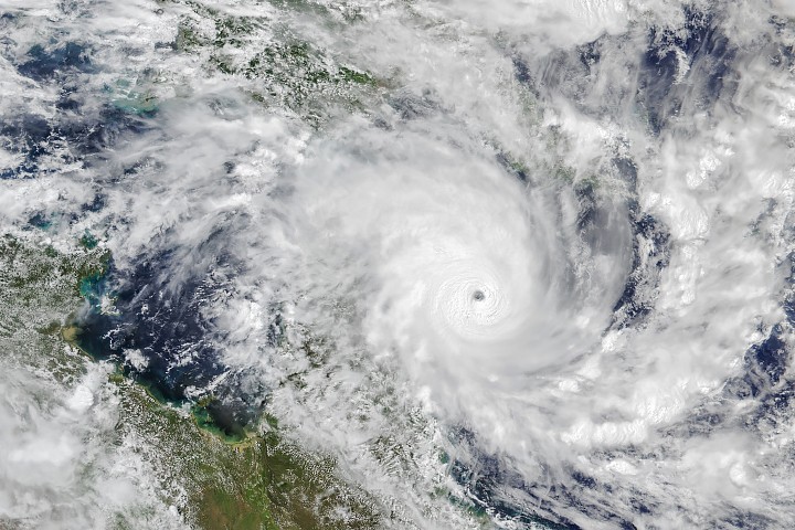
Winds exceeding 150 km/h are bearing down on Far North Queensland as Tropical Cyclone Narelle intensifies and closes in on the coast — and for communities stretching from Cairns to Innisfail, the message from authorities is clear: take cover now.
The system formed off the Queensland coast earlier this week and has strengthened rapidly, catching the attention of the Australian Bureau of Meteorology, which has issued urgent warnings across the region. What began as a developing low has grown into a severe tropical cyclone capable of significant damage to homes, infrastructure, and essential services.
For residents across the Far North, this is not a storm to watch from the window. Evacuation orders have already been issued in some areas, and the window to prepare is narrowing fast.
What Tropical Cyclone Narelle Is Bringing to the Coast
Narelle is tracking toward a coastline that includes some of Queensland’s most iconic and populated tropical communities. The Bureau of Meteorology has flagged a dangerous combination of hazards moving with the system — it’s not just the wind that poses a threat.
Authorities have warned that the cyclone is expected to produce:
- Sustained gusty winds exceeding 150 km/h
- Heavy and prolonged rainfall across coastal and inland areas
- Dangerous surf conditions along the Far North Queensland coastline
- Coastal flooding driven by storm surges
- Widespread disruption to infrastructure and vital services
Storm surges are often the deadliest element of a tropical cyclone — walls of seawater pushed inland by powerful winds that can flood low-lying areas within minutes. Combined with the heavy rainfall Narelle is expected to deliver, the risk of flash flooding both on the coast and further inland is significant.
The Towns in Narelle’s Path
Three communities have been specifically named by authorities as being in the zone of direct impact. Each faces its own set of vulnerabilities depending on proximity to the coast, elevation, and local infrastructure.
| Town / Area | Status | Key Risk |
|---|---|---|
| Cairns | High alert — preparation orders in place | Strong winds, storm surge, flooding |
| Port Douglas | High alert — preparation orders in place | Coastal flooding, dangerous surf |
| Innisfail | High alert — evacuation orders issued in some areas | Heavy rainfall, wind damage, flooding |
| Inland areas (Far North QLD) | On alert | Heavy rain, wind gusts, flash flooding |
Cairns, as the largest urban centre in the region, faces particular logistical challenges during a cyclone event — from hospital capacity and emergency services to the thousands of tourists and travellers who may be in the area at any given time. Port Douglas, a smaller coastal town north of Cairns, sits directly exposed to open ocean conditions. Innisfail, further south, has a history with severe cyclones and knows the toll they can take.
Why Narelle’s Rapid Intensification Is So Concerning
One of the most alarming aspects of this system is the speed at which it has strengthened. Rapid intensification — where a cyclone gains significant power in a short window — leaves less time for communities to prepare and for emergency services to pre-position resources.
Officials have noted that the damage potential from a cyclone of this strength is serious. Winds above 150 km/h can strip roofs, bring down trees and powerlines, and turn unsecured objects into dangerous projectiles. Infrastructure damage of this kind can knock out power and communications for days or even weeks in remote parts of Far North Queensland.
The combination of wind, rain, and storm surge means that even areas not directly in the cyclone’s eye can face life-threatening conditions. Inland communities that might feel distant from the coast are still exposed to flooding as rivers swell and overflow from the extraordinary rainfall totals these systems can deliver.
What Residents and Travellers Are Being Told to Do
Authorities have been direct in their messaging: residents in affected areas should not wait to see how the storm develops before acting. Preparation needs to happen now, while roads are still passable and conditions are manageable.
For those in or travelling through Far North Queensland, the practical advice being issued includes:
- Follow all evacuation orders immediately — do not attempt to shelter in place in designated evacuation zones
- Secure or bring inside any outdoor furniture, equipment, or objects that could become airborne
- Stock up on emergency supplies including water, food, medications, and battery-powered devices
- Stay informed through official Bureau of Meteorology updates and local emergency broadcasts
- Avoid unnecessary travel — roads in the cyclone’s path can become dangerous or impassable quickly
- Do not attempt to drive through floodwaters under any circumstances
For travellers, the message is equally clear. If you are in the region, check in with your accommodation provider and local tourism operators, and monitor official channels. Flight disruptions and road closures are likely as the system makes landfall.
What Comes Next as Narelle Moves Inland
Once a tropical cyclone crosses the coast, it typically begins to weaken as it loses the warm ocean water that fuels it. But that does not mean the danger ends at landfall. Narelle is expected to continue producing damaging winds and heavy rainfall as it tracks inland, meaning communities well away from the coast could still face serious flooding and wind damage in the hours and days following the initial impact.
Emergency services across Far North Queensland are on high alert, and the Australian Bureau of Meteorology is continuing to monitor and update Narelle’s track. Residents are urged to stay across the latest warnings, which can shift as the cyclone’s path becomes clearer.
The situation remains active and fast-moving. Anyone in the region should treat every official update as urgent and act accordingly.
Frequently Asked Questions
Where is Tropical Cyclone Narelle expected to make landfall?
Narelle is tracking toward the Far North Queensland coast, with communities including Cairns, Port Douglas, and Innisfail specifically named as being in the affected zone.
How strong are the winds from Cyclone Narelle?
Authorities have warned that Narelle is expected to produce gusty winds exceeding 150 km/h as it approaches the coast.
Have evacuation orders been issued?
Yes. Evacuation orders have been issued in some areas, according to authorities. Residents are urged to follow all official instructions from local emergency services.
Is there a risk of flooding beyond the immediate coastline?
Yes. The system is expected to bring heavy rainfall and the potential for coastal flooding from storm surges, with inland areas also at risk from the rainfall the cyclone carries.
Who issued the official warnings for Cyclone Narelle?
The Australian Bureau of Meteorology has issued urgent warnings for the region as the system intensifies.
Should travellers visiting Far North Queensland be concerned?
Yes. Travellers in the region are advised to monitor official updates closely, as flight disruptions and road closures are likely, and conditions across the affected area are expected to deteriorate rapidly.




Leave a Reply