
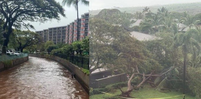
A rare and powerful weather system known as a Kona Low slammed into Hawaii in March 2026, triggering catastrophic flooding, mass evacuations, and widespread travel chaos across multiple islands — a crisis that caught both residents and visitors completely off guard.
Kona Lows are slow-moving, counterclockwise rotating storm systems that form near the Hawaiian Islands, typically during winter months. They’re unusual events — meteorologists note that a system of this severity strikes roughly once every decade. When one does hit, the consequences can be severe. The March 2026 event proved that in dramatic fashion.
The islands of Oahu, Maui, Molokai, and Lanai all bore the brunt of the storm, with torrential rainfall overwhelming drainage systems, flooding communities, and forcing emergency officials to act fast. For the thousands of tourists who had planned trips to paradise, the timing could not have been worse.
What a Kona Low Actually Does — and Why This One Was Different
Unlike tropical storms or hurricanes, a Kona Low doesn’t announce itself with dramatic wind speeds or a formal warning cone on the weather map. It works more slowly and insidiously, parking itself near the islands and dumping relentless rain over days rather than hours.
The March 2026 system was described as historic in scale. Communities north of Honolulu and throughout the Central Oahu valley faced some of the worst conditions, with evacuation orders issued as floodwaters rose rapidly. One of the most alarming developments was growing concern over the Wahiawa Dam on Oahu, which came under scrutiny as water levels climbed to dangerous levels.
On Maui, the story was similarly grim. Torrential rains battered the island, causing flooding that disrupted daily life and forced residents and tourists to seek higher ground or shelter in place.
Airport Chaos: Where the Travel Nightmare Began
For most visitors, the crisis became real the moment they checked their flight status. The storm caused significant disruptions at Hawaii’s two major gateway airports, compounding the misery for anyone trying to arrive, depart, or connect through the islands.
| Airport | Island | Status During Storm |
|---|---|---|
| Daniel K. Inouye International Airport (HNL) | Oahu | Severely disrupted operations |
| Kahului Airport (OGG) | Maui | Severely disrupted operations |
Flight delays and cancellations cascaded across both hubs, leaving thousands of travelers stranded in terminals or scrambling to rebook. For those already on the islands, getting to an airport — let alone catching a flight — became its own ordeal as roads flooded and emergency vehicles took priority.
Inter-island travel was equally complicated, with Molokai and Lanai also affected by the broader storm system. Smaller airports and ferry connections serving those islands faced their own set of disruptions, cutting off what are already relatively isolated communities from easy access to emergency resources and transportation alternatives.
Islands Affected and What Each One Faced
The reach of this Kona Low was unusually broad. Here’s a breakdown of which islands were hit and the primary impacts reported:
- Oahu: Evacuation orders issued for communities north of Honolulu and in the Central Oahu valley; Wahiawa Dam placed under monitoring due to rising water levels; major airport operations severely disrupted.
- Maui: Torrential rainfall and flooding across the island; Kahului Airport operations severely disrupted; widespread travel and community disruption.
- Molokai: Affected by the broader storm system; disruptions to travel and access reported.
- Lanai: Affected by the broader storm system; disruptions to travel and access reported.
The combination of flooding, evacuations, and transport shutdowns created a compounding crisis that emergency managers and tourism officials were forced to manage simultaneously.
What This Means If You Had a Trip Planned
If you were among the thousands with travel booked to Hawaii during this period, the situation presented a genuinely difficult set of choices. Flights were disrupted. Roads were flooded. Evacuation orders were in effect in parts of Oahu. And the infrastructure that tourists rely on — hotels, rental cars, tour operators, airport connections — was operating under serious strain.
Travel experts generally advise that when a destination is under active evacuation orders, travelers should contact their airline and accommodation providers immediately to understand their options. Many airlines activate travel waivers during declared emergencies, allowing passengers to rebook without fees. Travel insurance policies that include coverage for natural disasters or weather events may also provide relief, though the specifics depend heavily on the policy purchased and when it was bought relative to the storm’s development.
For those already in Hawaii during the storm, officials urged compliance with evacuation orders and avoidance of flooded roadways — conditions that can be far more dangerous than they appear on the surface.
What Happens Next for Hawaii’s Affected Islands
Recovery from an event of this scale takes time. Flood damage to roads, infrastructure, and communities doesn’t disappear when the rain stops. Oahu’s Wahiawa Dam situation, in particular, would require careful assessment before residents in surrounding areas could safely return.
For the tourism industry — which is central to Hawaii’s economy — the reputational and logistical fallout from a storm of this magnitude carries real consequences. Visitors who experienced canceled trips or difficult evacuations may be hesitant to rebook quickly, and operators across all four affected islands will be working to restore normal service levels as rapidly as conditions allow.
Meteorologists and emergency managers are likely to treat this event as a case study in Kona Low preparedness, given that these systems — while rare — are a known and recurring feature of Hawaii’s climate. The once-a-decade frequency means communities can go long stretches without a major event, which can erode preparedness over time.
Frequently Asked Questions
What is a Kona Low and how often does it hit Hawaii?
A Kona Low is a slow-moving, counterclockwise rotating storm system that forms near the Hawaiian Islands, typically in winter. A system of the severity seen in March 2026 occurs roughly once every decade.
Which Hawaiian islands were affected by the March 2026 storm?
Oahu, Maui, Molokai, and Lanai were all affected, with Oahu and Maui experiencing the most severe flooding and evacuation orders.
Which airports were disrupted during the Kona Low event?
Daniel K. Inouye International Airport (HNL) on Oahu and Kahului Airport (OGG) on Maui both experienced severely disrupted operations during the storm.
Was the Wahiawa Dam in danger during the flooding?
The Wahiawa Dam on Oahu was placed under growing concern as floodwaters rose, though
What should travelers do if they had trips booked to Hawaii during this event?
Travelers are generally advised to contact their airline and accommodation providers immediately, as many carriers issue travel waivers during declared emergencies; travel insurance with weather or natural disaster coverage may also apply.
When can tourists expect conditions to return to normal?
This has not been confirmed in available reporting — recovery timelines depend on the extent of infrastructure damage across each island and official assessments following the storm.

Leave a Reply