
▶ Read transcript
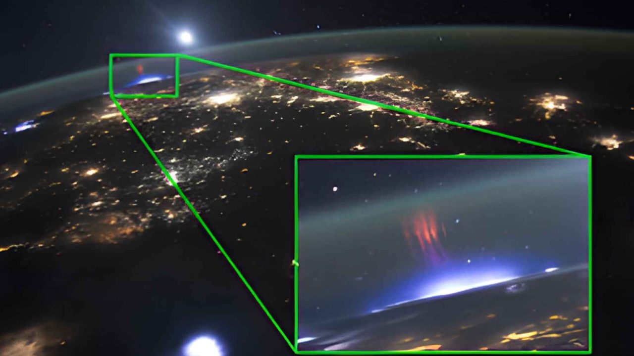
Here’s what you need to know about red sprites and the mysterious lightning that happens above thunderstorms. For decades, pilots reported seeing blood-red flashes erupting above storm clouds, but scientists dismissed them because the events lasted fewer than 20 milliseconds and existed in an observational blind spot too high for weather balloons and too low for most satellites. Everything changed in 1989 when University of Minnesota researchers accidentally captured a sprite on a low-light video camera, proving pilots had been right all along. Then in 2018, the European Space Agency mounted a specialized monitor on the International Space Station, turning it into the world’s most capable lightning observatory. Most recently, in July 2025, NASA astronaut Nichole Ayers photographed a rare gigantic jet from the ISS, a towering column of light bridging storm tops to the upper atmosphere. The takeaway: next time someone dismisses an observation for lack of evidence, remember it might just be waiting for the right instrument to catch it.
Have you ever seen something so fleeting, so improbable, that you doubted your own eyes? Imagine being a pilot at 35,000 feet, watching a blood-red explosion bloom above a thunderstorm, stretching dozens of miles into the upper atmosphere. You report it when you land. Nobody believes you.
That was the reality for aviators throughout much of the 20th century. They described crimson flashes erupting above storm clouds, vanishing in milliseconds. Scientists shrugged. Instruments couldn’t catch them. The phenomenon drifted into the same category as ball lightning and UFO sightings: interesting stories, zero evidence.
Then cameras on the International Space Station changed everything.
Why Scientists Dismissed Red Sprites for Over 50 Years
Most people assume lightning only strikes downward. It’s one of the most deeply ingrained mental images we have: a bright bolt cracking from cloud to ground. Textbooks reinforced it. Weather models relied on it. The idea that electricity could shoot upward from storm tops into near-space sounded, frankly, absurd.
Pilots who reported red or pink flashes above thunderstorms were met with polite skepticism at best. The flashes lasted fewer than 20 milliseconds. No ground-based camera in the mid-20th century could reliably capture something that fast, that high, and that faint against the night sky.
Without repeatable evidence, the phenomenon stayed in folklore. Atmospheric physicists had no framework for electrical discharges reaching 50 to 90 kilometers above sea level. The troposphere, where weather happens, tops out around 12 kilometers. What could possibly generate light five to seven times higher?
The 1989 Video That Cracked Open the Mystery
The first accidental recording of a sprite happened in 1989, when University of Minnesota researchers captured one on a low-light video camera during an unrelated experiment. That single frame of fuzzy red light above a distant storm was enough to rewrite the conversation.
Suddenly, pilots weren’t crazy. Something real was happening above thunderstorms. Researchers scrambled to classify what they were seeing, and the taxonomy grew quickly.
| Phenomenon | Altitude Range | Color | Duration |
|---|---|---|---|
| Red Sprites | 40–90 km | Red / Pink | ~5–20 ms |
| Blue Jets | 15–40 km | Blue | ~200–300 ms |
| ELVES | ~90 km | Red / UV rings | ~1 ms |
| Gigantic Jets | 19–90 km | Blue-to-Red | ~300–800 ms |
Red sprites, blue jets, ELVES, gigantic jets. Each type of transient luminous event operates at a different altitude, lasts a different duration, and carries different implications for atmospheric science. ELVES, for instance, spread as rings of optical and ultraviolet light near the bottom of the ionosphere, expanding outward at speeds that make sprites look sluggish.
But knowing these phenomena existed was only the beginning. Understanding them required a vantage point no ground-based observatory could provide.
The ISS Becomes a Lightning Laboratory at 400 Kilometers
In April 2018, the European Space Agency mounted the Atmosphere-Space Interactions Monitor (ASIM) outside the ISS Columbus laboratory module. ASIM was purpose-built to observe TLEs from orbit, equipped with photometers and X-ray/gamma-ray detectors capable of capturing events lasting less than a millisecond.
The station orbits at roughly 400 kilometers, circling Earth every 90 minutes. That orbital path carries it over thousands of thunderstorms each day. For the first time, scientists had a persistent, high-altitude platform staring directly down at the tops of storms, precisely where TLEs originate.
Another ISS experiment called Thor-Davis takes lightning observations and converts them into slow-motion sequences for detailed study. What the naked eye perceives as a single flash, Thor-Davis reveals as a complex cascade of electrical events unfolding in stages.
The combination of ASIM and Thor-Davis turned the ISS into something no one originally designed it to be: the world’s most capable lightning observatory.
Nichole Ayers and the Gigantic Jet of July 2025
On July 3, 2025, NASA astronaut Nichole Ayers was photographing storms from the ISS cupola when she captured something extraordinary. The image showed a towering column of light erupting from a storm top, reaching far into the upper atmosphere. She initially thought it was a sprite.
It wasn’t.
“This was a rare catch.”
— Burcu Kosar, Principal Investigator of the Spritacular project
Burcu Kosar, the principal investigator of NASA’s Spritacular project, confirmed it was a gigantic jet. Unlike sprites, which are triggered by cloud-to-ground lightning and propagate downward from the mesosphere, gigantic jets propagate upward from cloud tops. They act as an electrical bridge from storm tops around 12 miles up to the upper atmosphere around 62 miles up.
Gigantic jets are rarer than sprites, harder to photograph, and fundamentally different in their physics. They are not associated with cloud-to-ground lightning. They climb at a slower rate. And they terminate at altitudes approaching 90 kilometers, punching into the lower ionosphere itself.
You’re a commercial pilot flying at 41,000 feet over the Caribbean at night. You see a vivid red flash above a distant thunderstorm cluster, lasting less than a second. Your co-pilot didn’t see it. You need to decide how to respond.
Ayers’ photograph wasn’t just visually stunning. It provided data. The image, combined with ASIM readings, allowed researchers to measure the jet’s altitude, luminosity, and electrical characteristics with unprecedented precision.
Why 89-Kilometer Lightning Threatens Communications and Aircraft
TLEs aren’t just beautiful. They are consequential. According to an official space station research summary, transient luminous events can disrupt communication systems and pose a threat to both aircraft and spacecraft.
The ionosphere, where many TLEs terminate, is the atmospheric layer that reflects and refracts radio waves. High-frequency radio communication, GPS signals, and satellite links all depend on a stable ionosphere. When a gigantic jet or a cluster of ELVES dumps electrical energy into this layer, it can create localized disturbances that degrade signal quality.
For aircraft flying at high altitudes, particularly military and experimental craft above 60,000 feet, TLEs represent an electrical hazard that isn’t yet fully mapped. Sprites and jets occur above active thunderstorms, which pilots already avoid. But the electrical effects can extend laterally, reaching areas that appear clear of weather.
Climate scientists are also paying attention. TLEs may influence the chemistry of the mesosphere by generating nitrogen oxides at high altitudes, potentially affecting ozone concentrations. The scale of this effect remains under investigation, but the fact that it exists at all was unknown before ISS observations confirmed it.
What Red Sprites Mean for How We Understand Earth’s Electrical System
The traditional model of Earth’s electrical circuit was relatively simple. Thunderstorms act as generators, pushing current upward into the ionosphere, which then flows back down through fair-weather regions. It’s a global circuit, and for decades scientists believed it operated almost entirely within the troposphere.
TLEs shattered that model. They proved that thunderstorms don’t just push current gently into the upper atmosphere. They sometimes blast massive electrical discharges directly into the ionosphere, creating transient but powerful connections between the weather layer and near-space.
This matters for anyone who relies on satellite communications, GPS navigation, or aviation safety. It matters for climate models that need to account for chemical changes in the mesosphere. And it matters for our basic understanding of how the planet manages its electrical budget.
The Spritacular project, led by Kosar, now actively recruits citizen scientists to photograph TLEs from the ground, supplementing ISS data with observations from around the world. The more data points researchers collect, the closer they get to predicting when and where these events will occur.
For more than half a century, the people who actually saw red sprites were told they were wrong. Pilots, whose lives depend on sharp observation, were dismissed by scientists who had never looked out a cockpit window at 3 a.m. over the Gulf of Mexico.
The ISS proved the pilots right. And in doing so, it revealed that the sky above a thunderstorm is far stranger, far more violent, and far more connected to the edge of space than anyone had imagined. The next time you watch a distant storm flicker on the horizon, remember: the real show is happening 55 miles above it, in a place your eyes will never reach.


Leave a Reply