
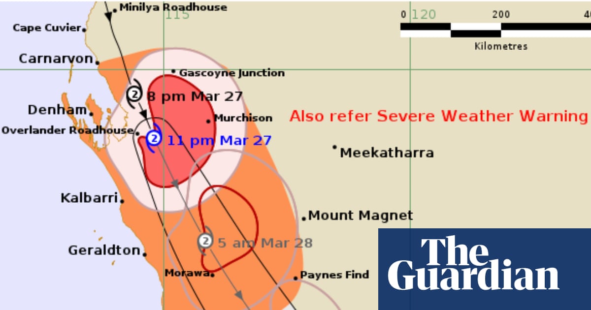
A tropical system that had spent days weakening across the northern tropics has roared back to life off the coast of Western Australia — and it is now tracking parallel to the Pilbara coastline with serious intensity. Tropical Cyclone Narelle has re-established itself as a formidable weather event, and meteorologists are warning that conditions could deteriorate rapidly in the hours ahead.
The storm’s resurgence is being driven by the warm ocean waters off Western Australia’s northwest coast, a fuel source that has allowed the system to transition back from a tropical low into a fully recognised cyclone. What makes this development particularly alarming is the speed of escalation: forecasters anticipate the system will climb to a severe Category 3 status imminently, with the potential to intensify further to a devastating Category 4 by tomorrow afternoon.
The zone of concern stretches across an enormous stretch of coastline — from the Kimberley region in the far north all the way down to Shark Bay in the south. That corridor includes some of Western Australia’s most visited and celebrated coastal destinations, putting both residents and travellers directly in the storm’s path.
How Tropical Cyclone Narelle Reached This Point
Narelle’s journey has been unusually drawn out. The system spent roughly a week moving across the northern tropics before losing enough strength to be downgraded. But the warm waters off Western Australia provided exactly the conditions needed for regeneration, and the storm has now come back stronger than many anticipated.
This kind of re-intensification is not unheard of during the Australian summer cyclone season, but it does make forecasting and preparation more complicated. Communities that may have relaxed their guard during the system’s weaker phase are now facing a compressed window to prepare for a potentially severe event.
The Pilbara coastline — a rugged, resource-rich stretch of Western Australia — sits directly in the storm’s current track. But the broader warning zone extends well beyond that, creating a state of elevated alert across a vast region of the state’s northwest.
The Affected Zone: Kimberley to Shark Bay
Understanding the scale of the threatened area matters. This is not a localised coastal warning affecting a single town. The disturbance spans an atmospheric corridor covering hundreds of kilometres of Australian coastline, encompassing dramatically different communities and landscapes.
| Region | Threat Level | Key Concern |
|---|---|---|
| Kimberley | High — northern extent of warning zone | Tropical conditions, heavy rainfall, flash flooding |
| Pilbara Coast | Severe — current storm track | Direct cyclone impact, destructive winds, storm surge |
| Shark Bay | Elevated — southern extent of warning zone | Coastal tourism destinations, heritage site exposure |
Shark Bay, a UNESCO World Heritage-listed area and one of Western Australia’s premier tourism drawcards, sits at the southern edge of the threat zone. The region attracts visitors for its extraordinary marine life, including the famous dolphin interactions at Monkey Mia, and its exposure to a Category 3 or 4 system would carry serious consequences for both infrastructure and the natural environment.
What This Means for Travellers and Coastal Communities
If you are currently travelling anywhere along the Western Australian northwest coast — or planning to — this storm demands your immediate attention. The scale of the warning zone means that the usual approach of simply moving a short distance inland or along the coast may not be sufficient.
Tourists staying in coastal accommodation between the Kimberley and Shark Bay should monitor official emergency management updates continuously and follow any evacuation instructions without delay. Cyclones at Category 3 and above produce winds and storm surges capable of destroying structures and making roads impassable within hours.
For those with upcoming travel plans to the region, the situation is evolving quickly. Flights, road access, and accommodation availability can all be disrupted with very little notice as a severe cyclone approaches. Travellers are strongly advised to contact airlines, tour operators, and accommodation providers directly and to check travel insurance coverage for weather-related cancellations.
Local residents in the affected corridor, particularly those in low-lying coastal areas, should treat any official evacuation order as an absolute priority. Storm surge — the wall of seawater pushed inland by cyclonic winds — is historically the most lethal element of tropical cyclones, and it can arrive with brutal speed.
What Happens as the Storm Develops
The next 24 hours are critical. The forecasted jump from Category 3 to Category 4 — if it occurs — would mark a significant escalation in destructive potential. Category 4 cyclones in Australia are associated with gusts exceeding 225 kilometres per hour and are capable of causing widespread structural damage, uprooting trees, and generating dangerous storm surges along exposed coastlines.
Emergency services across Western Australia are expected to be on heightened readiness throughout the storm’s approach. Road closures, school shutdowns, and evacuation orders for vulnerable coastal communities are all standard responses at this level of cyclone activity.
The storm’s eventual landfall location — if it makes landfall — will determine which communities face the worst of the conditions. A system tracking parallel to the coast can sometimes shift direction under the influence of broader atmospheric patterns, making ongoing monitoring essential rather than optional.
Anyone in or near the affected region should treat official guidance from Western Australia’s Department of Fire and Emergency Services as the authoritative source for real-time updates, evacuation zones, and safety instructions.
Frequently Asked Questions
What category is Tropical Cyclone Narelle currently?
The system has re-established itself as a cyclone and is expected to reach severe Category 3 status imminently, with Category 4 intensity possible by tomorrow afternoon.
Which parts of Western Australia are in the warning zone?
The warning zone spans a large section of the northwest coast, from the Kimberley region in the north down to Shark Bay in the south, with the Pilbara coastline sitting in the storm’s current track.
Is Shark Bay at serious risk from Cyclone Narelle?
Shark Bay sits at the southern extent of the disturbance warning zone, and as a coastal tourism destination it faces elevated risk from the system depending on the storm’s final track.
Should travellers cancel plans to the Western Australian northwest coast?
Anyone with upcoming travel to the region should contact airlines, tour operators, and accommodation providers directly and monitor official emergency updates closely, as conditions are evolving rapidly.
How did Narelle re-intensify after weakening?
The system spent about a week crossing the northern tropics before losing strength, then re-intensified over the warm waters off Western Australia’s northwest coast, which provided the energy needed to rebuild into a cyclone.
What is the most dangerous element of a Category 4 cyclone?
Storm surge — the rapid inundation of low-lying coastal areas by seawater driven by cyclonic winds — is historically the most lethal hazard associated with severe tropical cyclones.




Leave a Reply