
The exit off Interstate 55 that leads to Cahokia Mounds takes about four seconds to miss. That is, in a compressed way, the whole problem. As suburban development accelerates across the Metro East corridor of southwestern Illinois, the preserved core of what was once North America’s greatest pre-Columbian city sits less than nine miles from the Gateway Arch — announced by a single brown highway sign, visited by a fraction of the people who pass it every day.
Spring 2026 is an ideal window to go before summer heat settles over the American Bottom floodplain and before ongoing commercial development in Madison and St. Clair counties continues reshaping the land around the site’s buffer zone. New ground-penetrating radar and LiDAR surveys completed in recent years have revealed that Cahokia’s true footprint extends well beyond the protected acreage — which means the story of this place is still actively being written, and some of what it contains may not survive the decade.
A City That Shouldn’t Have Existed Here
The standard American history curriculum tends to leap from pre-contact indigenous cultures directly to European arrival, leaving a 1,500-year gap that includes one of the most sophisticated urban experiments in the Western Hemisphere. Cahokia was not a village or a seasonal camp. It was a planned city — with a central plaza, a ruling class, a solar calendar, and long-distance trade networks spanning the continent.
At its peak, roughly between 1050 and 1150 CE, the settlement covered approximately six square miles in the fertile floodplain where the Missouri and Illinois rivers converge near the Mississippi. The city’s population is estimated at between 10,000 and 20,000 within the urban core, with additional tens of thousands spread across satellite communities in the surrounding region. London’s population circa 1100 CE is estimated at approximately 10,000 to 15,000. The comparison is not rhetorical — it is structural. Two cities, same century, same scale, one of them taught in every school in the world and one accessible via a brown highway sign off I-55.
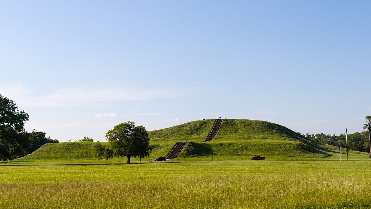
Monk’s Mound, the site’s centerpiece, rises 100 feet above the surrounding floodplain and covers approximately 14 acres at its base — a footprint slightly larger than that of the Great Pyramid of Giza. It was constructed entirely by hand, without metal tools, pack animals, or the wheel, using an estimated 22 million cubic feet of earth transported in woven baskets over multiple generations. A large wooden structure — interpreted by archaeologists as a chief’s residence or ceremonial hall — once stood at the summit.
The Grand Plaza, a man-leveled open expanse of roughly 50 acres at the city’s center, would have hosted public ceremonies, markets, and communal gatherings. Archaeologists have confirmed that the Mississippian builders removed and redeposited soil to create this perfectly flat surface — the kind of civic infrastructure that implies not just organized labor, but a governing authority capable of directing it.
What the Mounds Actually Contain
Much of what we know about Cahokia’s social structure has come from a relatively small number of excavations, which makes every new survey result significant. Mound 72, one of the smaller mounds on the south side of the site, produced one of the most striking burial assemblages ever found in North America.
Excavated during the 1960s and 1970s, Mound 72 held the remains of a high-status individual laid out on a bed of more than 20,000 marine shell beads arranged in the shape of a falcon — a bird with deep symbolic meaning in Mississippian cosmology. Surrounding this central burial were the remains of more than 250 other individuals, many of them young women, in arrangements that suggest ritual sacrifice at the death of a powerful leader. The find confirmed that Cahokia operated as a stratified society with a ruling class capable of commanding extraordinary resources and absolute obedience.
Cahokia Woodhenge, located roughly a quarter mile west of Monk’s Mound, consisted of large red cedar posts arranged in precise circles and positioned to align with sunrise on the summer and winter solstices and the spring and fall equinoxes. At least five successive woodhenges were built on the same location over time, each one slightly larger than the last — evidence of a community actively refining its astronomical knowledge across generations. A reconstruction of the most recent version stands on the site today.
The Disappearance That Still Has No Clean Answer
By approximately 1350 CE, Cahokia was effectively empty. The city that had drawn people from across the continent — trade goods from the Gulf Coast, the Great Plains, and the Great Lakes have all been recovered here — was abandoned within what archaeologists estimate as a few generations. The forest reclaimed the plazas. Smaller mounds were swallowed by soil and root systems.
No single explanation has achieved scholarly consensus, and that unresolved quality is part of what makes Cahokia so compelling to researchers working the site today. The leading theories include:
- Environmental degradation: The city’s demand for timber — for construction, fuel, and the woodhenge posts — may have stripped surrounding hillsides bare, triggering erosion and flooding of the low-lying plazas and agricultural zones.
- Climate disruption: A prolonged drought period in the 13th century, tied to broader Medieval Warm Period climate shifts, likely stressed the corn-based agricultural system that fed the urban population.
- Political fragmentation: The construction of a defensive wooden stockade around the central precinct — something that did not exist during Cahokia’s peak — suggests rising internal tensions, possibly between the ruling elite and outlying neighborhoods.
- Disease: A more recent hypothesis points to epidemic illness spreading through the densely settled population, though direct skeletal evidence remains limited and contested.
What the archaeological record makes clear is that the people did not vanish — they dispersed. Mississippian cultural traditions continued in communities across the Southeast and Midwest for centuries after Cahokia’s decline. The descendants of its residents almost certainly include members of modern tribes including the Osage, the Quapaw, and the Chickasaw, though establishing direct lineage with certainty remains an active area of research.
What Survives, What to Visit, and What’s Still at Risk
Cahokia Mounds State Historic Site encompasses roughly 2,200 acres of the original city. The Interpretive Center, located at 30 Ramey Street in Collinsville, Illinois, operates Tuesday through Sunday and charges a suggested donation of $7 for adults and $2 for children — the grounds themselves are free to walk. The site sits approximately eight miles east of the Gateway Arch, accessible via Interstate 55 at exit 6.
According to the UNESCO World Heritage listing, Cahokia represents “the most sophisticated prehistoric native civilization north of Mexico” — a designation that acknowledges both the site’s archaeological significance and the ongoing management challenges posed by its location within a developed urban corridor. The protected zone covers about 4,000 acres including a buffer area, but LiDAR surveys have identified features well beyond those boundaries now lying under agricultural fields and light industrial development.
The path to the top of Monk’s Mound is paved but genuinely steep in its upper sections. On a clear day, the St. Louis skyline is fully visible to the west across the floodplain — a disorienting juxtaposition that reframes everything. You are standing on the highest point of a city that predates St. Louis by roughly 600 years, looking at the skyline of a place that does not know it exists.
What Comes Next for Cahokia
The Illinois Historic Preservation Division and a consortium of university archaeologists have been building the case for expanded protections around the site’s buffer zone, particularly as commercial and residential development in the Metro East region has intensified over the past decade. The argument rests heavily on non-invasive survey work that keeps revealing new extent — underground features, postholes, refuse pits — in areas currently outside the protected boundary.
For visitors, the practical window is spring and fall. Temperatures are moderate, the grounds are green without the humidity of an Illinois summer, and the site never approaches the crowding of a national park. The equinox sunrise events at Woodhenge, organized by site staff each March and September, draw a dedicated group who come specifically to watch the sun rise in alignment with the reconstructed cedar posts — exactly as Cahokia’s residents witnessed it roughly nine centuries ago.
The drive from downtown St. Louis to the Interpretive Center takes under 20 minutes. The suggested donation costs less than a fast-food lunch. What the site returns is a specific, verifiable encounter with a piece of American history that most curricula have never taught — a city of 20,000 people, built without metal or wheels, that rose and fell and left behind 80 earthen monuments still visible from the air. The exit off I-55 is easy to miss. It is worth making a point of not missing it.
Related: The Cloud Valley Trail Above Landour That Most Mussoorie Tourists Never Find
.pvv-faq-section details summary::-webkit-details-marker{display:none}.pvv-faq-section details summary::marker{display:none;content:””}.pvv-faq-section details[open] summary .pvv-faq-arrow{transform:rotate(90deg)}

Leave a Reply