
▶ Read transcript
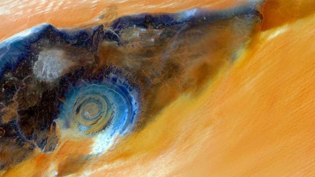
Here’s what you need to know about the giant eye staring up from the Sahara Desert. NASA’s Earth Observatory released new International Space Station photos on April 26th, 2026, of a formation called the Richat Structure, also known as the Eye of the Sahara. It’s a massive circular feature in Mauritania, roughly 50 kilometers across, and it’s so visually striking that astronauts have used it as a navigation landmark since the earliest days of crewed spaceflight. Despite looking exactly like a meteor crater from above, it isn’t one. Scientists found none of the telltale signs of an impact, and the real explanation is actually more fascinating — it’s a deeply eroded geological dome, with the oldest rocks exposed at the center and progressively younger layers radiating outward. If this caught your curiosity, look up NASA’s Earth Observatory website, where the latest ISS images are publicly available and free to explore.
What if the desert was watching you back?
When astronauts aboard the International Space Station peer down at the Sahara, a vast, featureless ocean of sand and rock stretches in every direction. Then, suddenly, something breaks the monotony. A perfect, concentric ring structure, enormous and unmistakably eye-shaped, stares upward from the Mauritanian desert floor.
NASA’s Earth Observatory published fresh ISS imagery of this structure on April 26, 2026, reigniting public fascination with one of Earth’s most visually stunning geological formations. The question that always follows: what on Earth made that?
Why the Eye of the Sahara Stops Astronauts Cold
The Sahara is the largest hot desert on Earth, covering roughly 9 million square kilometers. From orbit, it looks almost textureless: brown, tan, ochre, repeating endlessly. That visual uniformity is exactly why the Richat Structure commands such immediate attention from space.
Astronauts have been drawn to it since the earliest crewed missions. With no GPS or digital mapping to guide early spaceflight navigation, crew members used distinctive landmarks to orient themselves. The Richat Structure, sitting in western Mauritania near the city of Ouadane, was one of the most reliable visual anchors available from low Earth orbit.
The structure is approximately 50 kilometers wide, with NASA describing it as about 25 miles across. Some geological surveys push that estimate to 28 or even 30 miles depending on where the outer boundary is drawn. Either way, it is large enough to be unmistakable from 400 kilometers above the planet’s surface.
The most recent ISS photographs place the structure in stunning context. Surrounding it, the Sahara sprawls in every direction with no competing visual feature for hundreds of kilometers. The Eye does not just stand out. It dominates.
Five Reasons the Richat Structure Is More Extraordinary Than It Looks
Most people encounter the Eye of the Sahara as a single aerial image and move on. That is a mistake. The more you learn about this formation, the stranger and more impressive it becomes. Here are five layers of discovery, building toward the most surprising fact of all.
5. Middle School Students Have Photographed It from Space
This is not just a NASA scientist’s playground. Through a program called the Sally Ride EarthKAM, middle school students have programmed a camera aboard the International Space Station to photograph specific targets on Earth’s surface, including this portion of the Sahara desert.
Students select coordinates, submit their camera commands, and receive actual ISS imagery in return. The Richat Structure has been a popular target precisely because it photographs so dramatically. Young people are doing real orbital science, pointing real hardware at one of Earth’s most enigmatic features.
4. It Was Mistaken for a Meteor Impact Crater for Decades
When geologists first studied the Richat Structure seriously in the mid-20th century, the circular shape seemed like an obvious giveaway. A meteorite impact, they reasoned, would produce exactly this kind of concentric ring pattern in the surrounding rock. The hypothesis was clean, intuitive, and wrong.
Detailed field surveys found no shatter cones, no shocked quartz, and no iridium anomalies — the standard forensic signatures of a hypervelocity impact event. The meteorite hypothesis quietly collapsed under the weight of evidence. What replaced it was far more interesting.
3. The Rings Are Made of Progressively Older Rock
Here is where the geology becomes genuinely strange. In a typical landscape, older rock layers sit below younger ones. At the Richat Structure, the pattern runs outward instead of downward. The oldest rocks are exposed at the center. Moving outward through each concentric ring, the rock layers become progressively younger.
This happens because the structure is a dome. Over millions of years, erosion stripped away the upper layers, exposing the ancient core at the center while leaving younger surrounding layers intact at greater distances. You are not looking at a hole. You are looking at a bulls-eye cross-section of deep geological time.
| Feature | Meteor Impact Crater | Richat Structure (Dome) |
|---|---|---|
| Rock age pattern | Disrupted, mixed | Older at center, younger outward |
| Shocked quartz present | Yes | No |
| Iridium anomaly | Often present | Absent |
| Formation mechanism | Hypervelocity impact | Dome uplift and differential erosion |
| Diameter | Varies widely | ~50 kilometers |
2. The Circular Ridges Have a Specific Geological Name
Those concentric rings are not random. They are called cuestas, a geological term for asymmetric ridges formed when rock layers of different hardness erode at different rates. As the dome was exposed over millions of years, harder rock resisted erosion and stood up as ridges. Softer rock between them wore away into valleys.
You are reviewing ISS photographs of the Sahara and notice a perfect 50-kilometer circular ring structure. You have no prior knowledge of the Richat Structure. What is your first instinct about its origin?
The result is a series of nested, circular ridges and troughs, each one representing a different rock type and a different chapter in Earth’s deep history. From the ground, the cuestas look like low walls. From orbit, they look like the rings of an eye.
The Real Origin: A Domed Anticline Hiding in Plain Sight
This is the number one most important thing to understand about the Eye of the Sahara, and it is the fact that most popular coverage gets wrong or glosses over entirely.
The Richat Structure is classified geologically as a domed anticline. An anticline is a type of fold in rock layers where the strata arch upward. A domed anticline is one where that upward arching occurs symmetrically in all directions, producing a circular or oval dome shape rather than a linear ridge.
The dome formed through a combination of geological forces acting on the ancient rocks of the West African Craton, one of the oldest and most stable sections of Earth’s continental crust. Magma intruded into the crust, pushing layers upward. Over vast stretches of time, erosion did the rest, carving the concentric rings we see today.
“The Eye of the Sahara is a window into deep time. Each ring is a layer of Earth’s history, peeled back and laid bare by millions of years of wind and water.”
— NASA Earth Observatory description of the Richat Structure
What makes the Richat Structure so visually perfect is the near-total absence of vegetation, soil cover, or human development across this part of the Sahara. In most parts of the world, a geological dome of this scale would be invisible from the air, buried under forests, farms, or cities. Here, the desert has stripped everything away, leaving the raw rock architecture fully exposed.
The Eye does not just look dramatic from space. It is a rare case where the surface of the Earth has been worn down to its structural skeleton, and that skeleton happens to be circular, layered, and enormous. You are not seeing something unusual about the Sahara. You are seeing something usual about the Earth, made visible only because the desert removed everything that would normally hide it.
What the Eye of the Sahara Tells Us About Looking at Earth
There is a broader lesson embedded in this story. For decades, scientists looked at the Richat Structure and saw a meteor crater because that is what a circular feature in a desert was supposed to be. The evidence was right there in the rock, but the assumption was strong enough to delay the correct interpretation for years.
The same thing happens in reverse with the public. The Eye of the Sahara looks cosmic, alien, almost engineered. It invites speculation about ancient civilizations, lost cities, and extraterrestrial origins. Those theories circulate endlessly online, precisely because the structure is so visually extraordinary.
But the actual explanation, a dome of ancient rock slowly peeled open by millions of years of desert erosion, is if anything more impressive than a meteor strike. It is a record of forces operating across timescales that make human history look like a rounding error.
The next time an astronaut floats to a window on the ISS and looks down at that perfect circle staring back from the Mauritanian desert, they are not seeing something alien. They are seeing the planet’s own slow, patient, relentless work — and it has been going on long before anyone was up there to notice it.




Leave a Reply