
What would you think if you looked down at Earth from space and saw a brown stain the length of an entire continent spreading across one of its most vital oceans? Would you assume it was a trick of the light? A satellite glitch? Or would you lean in closer, uneasy, suspecting that something had gone profoundly wrong?
That is precisely the question scientists have been wrestling with since satellite imagery began capturing the Great Atlantic Sargassum Belt in clearer and more alarming detail each passing year. The brown ribbon is real. It is growing. And it is now one of the most closely watched phenomena in ocean science.
To understand why this matters, you need to zoom out, both literally and figuratively. This is not just a patch of floating seaweed. It is a mirror held up to the health of the entire Atlantic Ocean. Here are five key dimensions of the sargassum crisis, ranked by their long-term consequences for the planet.
5. The Saharan Dust Connection: How Desert Sand Feeds an Ocean Bloom
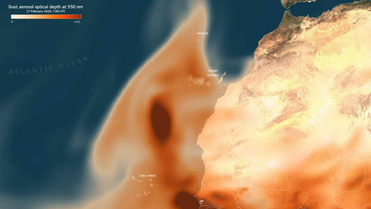
The story of the brown ribbon does not begin in the ocean. It begins in the Sahara Desert, thousands of miles away. Since mid-February 2026, a broad calima event — a dense mass of Saharan dust carried west by trade winds — has been streaming across the eastern Atlantic.
On February 17, 2026, the Meteosat-12 satellite, orbiting approximately 22,400 miles above Earth, captured dramatic images of the dust plume pushing westward over the open ocean. The Copernicus Atmosphere Monitoring Service issued analyses and short-range forecasts tracking the aerosols. Residents in the Canary Islands, Cabo Verde, and Madeira received outdoor-time warnings as PM10 particles — tiny mineral specks capable of irritating eyes and airways — blanketed the region.
Here is the twist that most people miss: that same mineral dust, when it settles on the ocean surface, acts as a fertilizer. It deposits iron, phosphorus, and nitrogen into nutrient-poor tropical waters. Phytoplankton blooms. The base of the food chain surges. And organisms like sargassum seaweed, which thrive on elevated nutrients, get a free meal delivered from the sky.
4. A Belt the Length of a Continent: The Scale of the Great Atlantic Sargassum Belt
Numbers can numb. So consider this instead: if you drove the length of the Great Atlantic Sargassum Belt at highway speed, stopping for nothing, it would take you over four days to reach the other end.
The belt now spans more than 8,850 kilometers, stretching from the coast of West Africa all the way to the Gulf of Mexico. A research team led by Mengqiu Wang at the University of South Florida has been tracking it via satellite imagery since 2011. What they documented in 2025 was staggering: sargassum reached record levels in parts of the Atlantic and Caribbean Sea, surpassing previous highs that had themselves seemed extraordinary just a few years earlier.
What makes the belt unusual is its persistence. Sargassum has always existed in the Atlantic. But before 2011, it did not form a continuous, nearly unbroken ribbon linking two continents. Something changed. And scientists have strong hypotheses about what.
3. A Moving Habitat on the Verge of Collapse
Not everything about sargassum is alarming. In fact, in its natural, open-ocean state, it is one of the ocean’s most vital ecosystems.
Sargassum provides shelter for fish, sea turtles, crabs, shrimp, and dozens of other small animals. Scientists describe it as a moving habitat — a floating island of biodiversity drifting across an otherwise featureless stretch of open ocean. Baby loggerhead sea turtles rely on sargassum patches for protection during their first years of life. Juvenile flying fish, mahi-mahi, and amberjack all use the weed as nursery habitat.
“Sargassum in the open ocean is a critical habitat. The problem is not sargassum itself — it is sargassum in the wrong place, at the wrong density, for the wrong reasons.”
— Ocean scientists studying the Great Atlantic Sargassum Belt
When the belt grows too large, the dynamic shifts. Massive accumulations wash ashore on Caribbean and Gulf Coast beaches, burying nesting sites for sea turtles and suffocating coral reefs in shallow waters. As the seaweed rots on beaches, it releases hydrogen sulfide gas, a toxic compound that smells like rotten eggs and poses real health risks to coastal communities.
The paradox is brutal: the very organism that supports ocean life in open water becomes a destroyer of coastal ecosystems when it arrives in overwhelming quantity.
2. Nitrogen and the Human Fingerprint on the Atlantic’s Chemistry
Why did the belt begin its explosive growth around 2011? The desert dust helps explain seasonal fluctuations. But the underlying driver points back to human activity on land.
Agricultural runoff from South American river systems, particularly the Amazon and Congo basins, has been dumping increasing quantities of nitrogen and phosphorus into the Atlantic. Deforestation accelerates this process by reducing the land’s capacity to absorb nutrients before they reach rivers. Warmer ocean temperatures, driven by climate change, further stimulate sargassum growth by altering ocean circulation patterns that once kept nutrients in check.
| Driver | Source | Effect on Sargassum |
|---|---|---|
| Saharan dust (calima events) | North Africa, atmospheric transport | Deposits iron and nutrients onto ocean surface |
| Agricultural nitrogen runoff | Amazon and Congo river basins | Elevates ocean nutrient levels persistently |
| Rising ocean temperatures | Climate change, CO2 emissions | Expands the growth zone, disrupts circulation |
| Deforestation | South America, West Africa | Reduces nutrient absorption before river runoff |
The belt, in other words, is not a natural anomaly. It is a readout of the cumulative pressure human civilization has placed on the Atlantic’s chemistry over decades. Each year the ribbon grows, it is writing a new line in that ledger.
The Number 1 Threat: What the Brown Ribbon Actually Signals About Ocean System Collapse
Every item on this list is serious. But the most alarming dimension of the Great Atlantic Sargassum Belt is not what it is. It is what it means.
The belt is a symptom of a broader ocean system under stress. Scientists studying it have begun describing it as an indicator species for Atlantic ecosystem health — much like a canary in a coal mine, except the canary is 8,850 kilometers long and visible from space.
When an ocean produces a seaweed bloom of this magnitude, persistently, year after year, it signals that the nutrient balance of the entire system has shifted. That shift does not stay contained to sargassum. Hypoxic zones — areas where oxygen levels drop so low that fish cannot survive — expand in the wake of massive blooms. Coral reefs smothered by rotting sargassum on the seafloor lose the photosynthetic capacity that keeps them alive. Fisheries dependent on clear, balanced coastal waters face disruption at a scale that economic models are only beginning to quantify.
There is also the atmospheric dimension. As the belt decomposes in coastal zones, it releases carbon back into the atmosphere that the living seaweed had temporarily locked away. An ocean system that should be acting as a carbon sink begins, in localized zones, to function as a carbon source. The implications for climate feedback loops are not yet fully understood, which is precisely what worries scientists most.
Scientists at the University of South Florida and monitoring agencies like the Copernicus Atmosphere Monitoring Service are now building more sophisticated models to track how calima events interact with the belt’s growth cycles. The goal is early warning: knowing when conditions are aligning for a particularly destructive bloom season before it arrives on Caribbean shores.
But modeling is not the same as solving. The nutrient drivers are embedded in agricultural systems, deforestation patterns, and climate trajectories that no single research team or government agency can reverse quickly. The brown ribbon is a long-term problem wearing a very visible face.
What the Sargassum Belt Tells Us About the Limits of Ignoring Ocean Health
The ranking presented here moves from the peripheral to the central for a reason. Dust storms are vivid and photogenic. Record-breaking scale statistics are easy to share. The loss of a coastal ecosystem is tangible and local. But the systemic signal, the possibility that the Atlantic is entering a new and less stable equilibrium, is the thing that should concentrate minds in research labs, policy offices, and ordinary households alike.
The belt is not going away. It is a feedback loop now, fed by warming oceans, by runoff from deforested land, by dust from a drying Sahara, and by decades of treating the ocean as a system with infinite capacity to absorb whatever we put into it.
The most unsettling thing about the brown ribbon is not that it exists. It is that it took us until it was visible from space to start paying close attention.
Frequently Asked Questions

You Might Also Like
5 Ways Satellite Data on Shifting Vegetation Will Reshape Farming
Satellites show Earth's vegetation center drifting north at accelerating rates. Here are 5 ways this…

The Secret Science Behind a Nuclear Carrier’s Final Atlantic Test
USS George H.W. Bush completed COMPTUEX in the Atlantic before deployment. Here's the science and…
5 Clues From a Hidden Fossil That May End the 160-Year Bird Flight Debate
A hidden Archaeopteryx fossil reanalyzed with CT scans and UV light reveals 5 clues that…
Leave a Reply