
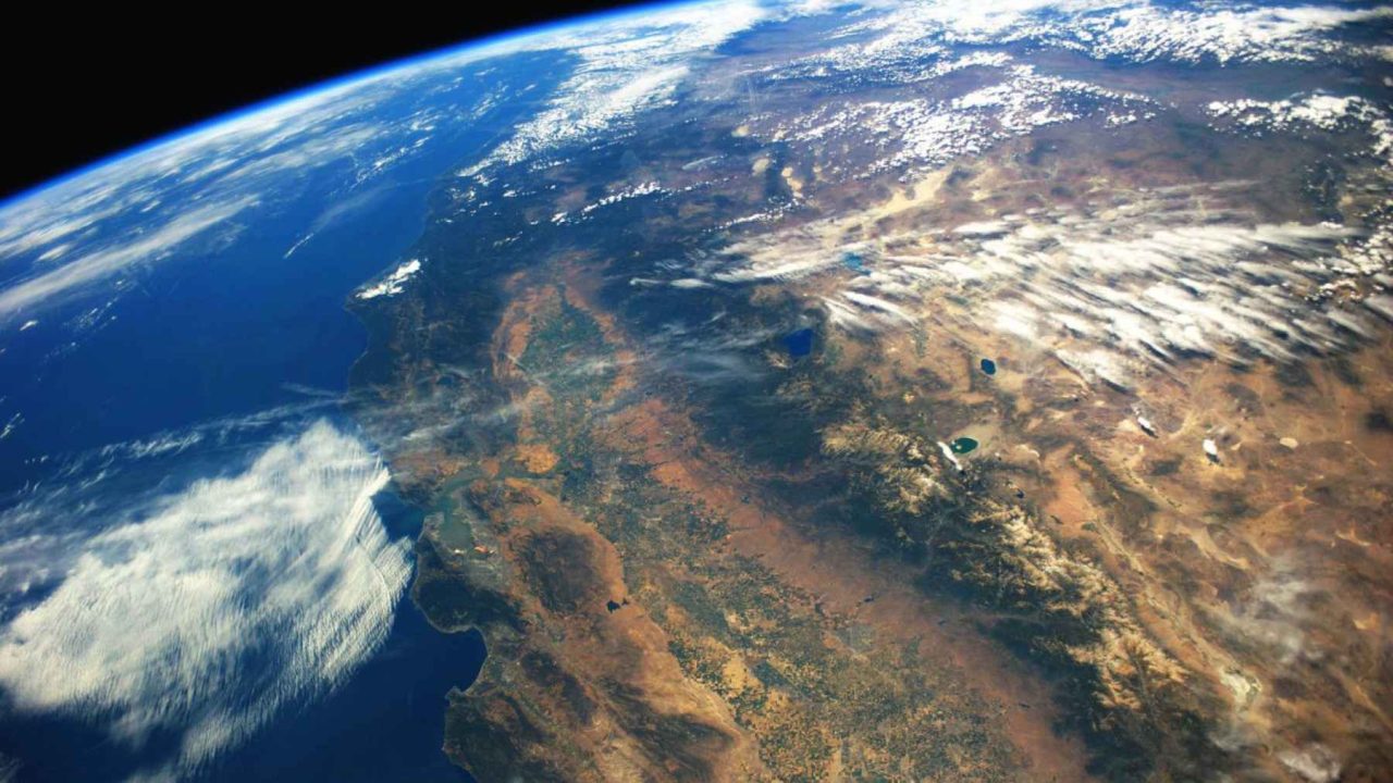
The Cascadia subduction zone is capable of producing earthquakes close to magnitude 9.0, large enough to send tsunamis crashing across the entire Pacific Ocean. Scientists have spent decades mapping every fault line, every plate boundary, every stress point in that system. They thought they had a reasonably complete picture.
They were wrong. Buried beneath the meeting point of three tectonic plates in northern California, a fragment of ancient seafloor has reappeared after 200 million years of geological silence. Researchers call it the Pioneer fragment, a surviving shard of the Farallon plate, and its confirmed existence is rewriting what geologists thought they understood about one of the most seismically active corners of North America.
This is not a minor update to an old map. A study published in the journal Science reveals that the region contains at least five distinct moving pieces of crust where classic models showed only three. That difference, measured in kilometers of unexpected plate contact and seismic stress, could matter enormously to millions of people living along the Pacific Coast.
Here are five discoveries from that research, counted down to the one that changes everything.
#5: A Plate That Died When Dinosaurs Hadn’t Yet Evolved
To understand why the Pioneer fragment matters, you need to understand how old it is and where it came from. The Farallon plate began sinking into the Earth’s mantle roughly 200 million years ago, during the breakup of the supercontinent Pangaea. That’s before the first dinosaurs had established dominance. Before the Atlantic Ocean existed as we know it.
The Farallon was a vast oceanic plate that once covered much of what is now the Pacific basin. As Pangaea fractured and North America drifted westward, the Farallon was slowly consumed by the advancing continent, ground downward into the mantle through a process called subduction. Over millions of years, the plate effectively disappeared beneath North America, leaving only scattered fragments and indirect evidence of its former existence.
The Pioneer fragment is one of those survivors. Approximately 30 million years ago, instead of sinking with the rest of the Farallon, this particular chunk was captured by the Pacific plate, the largest tectonic plate on Earth at roughly 103 million square kilometers. It has been migrating northward ever since, hitching a ride on the Pacific plate while its ancient siblings dissolved into the deep mantle below.
For geologists, finding it is roughly equivalent to discovering a species scientists declared extinct centuries ago, still alive and quietly moving through the ecosystem.
#4: The Triple Junction Nobody Fully Understood
The Pioneer fragment sits near one of the most geologically complicated spots on the planet: the Mendocino Triple Junction, located off the coast of northern California near Eureka. This is where three major tectonic plates intersect. The Pacific plate, the North American plate, and the Gorda plate all meet at this single point.
Triple junctions are inherently unstable. Three plates pulling or pushing in different directions create zones of intense stress that migrate over time. The Mendocino Triple Junction has been slowly creeping northward for millions of years, dragging seismic complexity with it along the California and Oregon coasts.
| Plate | Role at Mendocino Triple Junction | Key Risk |
|---|---|---|
| Pacific Plate | Moves northwest, carries Pioneer fragment | Transfers lateral stress to faults |
| Gorda Plate | Subducts beneath North America | Drives Cascadia earthquake risk |
| North American Plate | Overrides Gorda, absorbs stress | Hosts San Andreas fault system |
| Pioneer Fragment | Newly confirmed moving piece | Extends plate contact zone southward |
| N. American Fragment | Broken shard sinking with Gorda | Adds unknown stress to fault geometry |
The new research adds the Pioneer fragment and a broken piece of the North American plate itself to this already complex puzzle. Five moving pieces where three were expected is not a small revision. It is a structural rethinking of how stress distributes through the entire region.
#3: The Cascadia Zone Is Bigger Than Anyone Mapped
Here is where the data begins to feel urgent. The new geometric model of the Pioneer fragment shows that the main plate interface, the actual boundary where one plate slides beneath another, extends farther south than previous maps indicated.
That southward extension increases the contact area between the subducting plate system and the North American plate above it. More contact area means more surface where stress can accumulate. It means more fault surface capable of rupturing in a major earthquake.
Scientists have long modeled Cascadia’s southern limit as roughly near Cape Mendocino in northern California. If the Pioneer fragment is extending the active subduction interface southward of that point, the hazard zone creeps closer to more densely populated areas. The cities of the San Francisco Bay Area and Sacramento valley sit not far from where these tectonic revisions are being drawn.
Revised geometry doesn’t automatically mean a larger earthquake. But it does mean scientists may have been miscalculating where the energy builds and where it releases, which affects every seismic hazard model built on those older maps.
#2: Part of North America Is Already Breaking Apart
The fourth major discovery from the Science paper may be the most viscerally unsettling. Researchers identified a chunk of the North American plate that has broken off from the main mass and is sinking alongside the Gorda plate into the mantle below.
Tectonic plates are supposed to be coherent units. The idea that a recognizable piece of North America has detached and is actively descending into the Earth introduces a new variable into regional seismic models. Delamination, as geologists call this kind of plate fragmentation, creates pressure imbalances and stress transfers that are difficult to predict.
When rock descends into the mantle, it changes the thermal and pressure environment around it. That can trigger seismic activity along fault lines nowhere near the sinking fragment itself. Geophysicists are still working out the full implications of this particular piece of detached North America, but its existence alone forces a reassessment of how stable the region’s subsurface geometry actually is.
#1: The Pioneer Fragment Is Sitting Exactly Where You Wouldn’t Want It
The number one discovery, the one that brings all the others into alarming focus, is this: the Pioneer fragment sits directly beneath northern California at the precise point where the San Andreas fault system and the Cascadia subduction zone meet.
That is not a coincidence of geography. It is the geological crux of western North America’s seismic architecture. The San Andreas fault runs roughly 1,300 kilometers through California, responsible for major earthquakes including the catastrophic 1906 San Francisco event. The Cascadia subduction zone runs along the Pacific Northwest coast, capable of a magnitude 9.0 rupture. These two systems are the dominant seismic threats to tens of millions of people.
“The new model identifies at least five moving pieces beneath the surface, compared to the classic map showing only three plates. The geometry extends the main plate interface farther south than previously thought, increasing contact area with the Cascadia subduction zone.”
— Findings from the study published in Science
The Pioneer fragment occupies the junction between these two systems. Its movement, carried northward on the Pacific plate for 30 million years, has been quietly reshaping the stress environment at one of the most seismically sensitive points on the continent. And because the fragment was considered dormant, essentially absent from geologists’ active models, its influence on the surrounding fault geometry was never accounted for.
#pvv_bar_chart_1775670399230_63on1r {
font-family: -apple-system, BlinkMacSystemFont, ‘Segoe UI’, Roboto, sans-serif;
margin: 2rem 0;
border-radius: 12px;
box-shadow: 0 4px 24px rgba(0,0,0,0.08);
background: #fff;
overflow: hidden;
}
#pvv_bar_chart_1775670399230_63on1r .pvv-bc-header {
background: linear-gradient(135deg, #2d3436 0%, #636e72 100%);
color: #fff;
padding: 1.25rem 1.5rem;
font-size: 1.15rem;
font-weight: 700;
}
#pvv_bar_chart_1775670399230_63on1r .pvv-bc-body { padding: 1.5rem; }
#pvv_bar_chart_1775670399230_63on1r .pvv-bc-row {
display: flex;
align-items: center;
margin-bottom: 0.75rem;
}
#pvv_bar_chart_1775670399230_63on1r .pvv-bc-label {
width: 120px;
flex-shrink: 0;
font-size: 0.85rem;
font-weight: 600;
color: #2d3748;
text-align: right;
padding-right: 1rem;
white-space: nowrap;
overflow: hidden;
text-overflow: ellipsis;
}
#pvv_bar_chart_1775670399230_63on1r .pvv-bc-track {
flex: 1;
height: 32px;
background: #f7fafc;
border-radius: 6px;
overflow: hidden;
}
#pvv_bar_chart_1775670399230_63on1r .pvv-bc-bar {
height: 100%;
border-radius: 6px;
display: flex;
align-items: center;
justify-content: flex-end;
padding-right: 8px;
min-width: 40px;
}
#pvv_bar_chart_1775670399230_63on1r .pvv-bc-value {
font-size: 0.75rem;
font-weight: 700;
color: #fff;
white-space: nowrap;
text-shadow: 0 1px 2px rgba(0,0,0,0.2);
}
#pvv_bar_chart_1775670399230_63on1r .pvv-bc-vertical {
display: flex;
align-items: flex-end;
justify-content: space-around;
height: 250px;
padding: 0 1rem;
border-bottom: 2px solid #e2e8f0;
}
#pvv_bar_chart_1775670399230_63on1r .pvv-bc-vcol {
display: flex;
flex-direction: column;
align-items: center;
flex: 1;
max-width: 60px;
height: 100%;
justify-content: flex-end;
}
#pvv_bar_chart_1775670399230_63on1r .pvv-bc-vbar {
width: 70%;
border-radius: 6px 6px 0 0;
min-width: 24px;
min-height: 4px;
}
#pvv_bar_chart_1775670399230_63on1r .pvv-bc-vlabel {
margin-top: 0.5rem;
font-size: 0.72rem;
font-weight: 600;
color: #4a5568;
text-align: center;
word-break: break-word;
}
#pvv_bar_chart_1775670399230_63on1r .pvv-bc-vvalue {
font-size: 0.7rem;
font-weight: 700;
color: #718096;
margin-top: 0.2rem;
}
@media (max-width: 640px) {
#pvv_bar_chart_1775670399230_63on1r .pvv-bc-label { width: 80px; font-size: 0.75rem; }
#pvv_bar_chart_1775670399230_63on1r .pvv-bc-track { height: 26px; }
#pvv_bar_chart_1775670399230_63on1r .pvv-bc-header { font-size: 1rem; padding: 1rem; }
#pvv_bar_chart_1775670399230_63on1r .pvv-bc-vertical { height: 180px; }
}
The researchers used thousands of low-frequency earthquakes and deep underground tremors to track the fragment’s position and motion. These low-frequency events are subtle, often imperceptible at the surface, but they reveal the mechanical conversation happening between rock masses kilometers beneath the ground. What the seismometers heard told a story nobody had written into the textbooks yet.
The practical consequence is that every seismic hazard model built for northern California and the southern Cascadia region may need revision. The contact geometry is different from what was assumed. The number of moving parts is higher. The southern extent of the subduction interface is larger. These are not abstract academic corrections. They feed directly into building codes, emergency preparedness plans, and probabilistic earthquake forecasts that governments and insurers rely on.
What This Means for the Millions Living Above It
Geological discoveries don’t make headlines the way earthquakes do. A paper in a scientific journal rarely triggers the urgency it deserves, especially when the subject is something invisible, ancient, and moving at speeds measured in centimeters per year. But the Pioneer fragment’s confirmation is the kind of finding that quietly reshapes risk assessments for decades.
Northern California’s seismic monitoring networks will almost certainly be updated in light of this research. Cascadia hazard models used by FEMA, state emergency agencies, and the insurance industry all depend on accurate plate geometry. A boundary that extends farther south than expected is a hazard that extends farther south than expected.
For residents of Humboldt County, the Bay Area, and the communities along the northern California coast, the message isn’t panic. It’s awareness. The ground beneath you has more moving parts than the maps suggested. That knowledge, uncomfortable as it is, is exactly the kind that saves lives when translated into better building standards and more realistic emergency planning.
A plate that spent 200 million years in geological obscurity has made its presence known. The Earth, it turns out, was never finished rearranging itself. It was just doing it quietly, where no one was looking.
.pvv-faq-section details summary::-webkit-details-marker{display:none}.pvv-faq-section details summary::marker{display:none;content:””}.pvv-faq-section details[open] summary .pvv-faq-arrow{transform:rotate(90deg)}
Frequently Asked Questions

You Might Also Like
Victoria’s Giant Ball of Light Was a Dying Satellite, Not a Meteor
A blazing orange ball stunned Victoria residents on April 7, 2026. Astronomers identified it as…

The Bear Is Not a Predator: 5 Findings That Rewrite Wildlife Science
A 2025 Nature Communications study reveals bears have shifted toward plant-based diets since the last…
Beneath Czech Farmland, 2,918 Ancient Sites Rewrite Burial History
Archaeologists found 2,918 hidden sites under Czech farmland, including 5,000-year-old Neolithic burial mounds that reshape…
Leave a Reply